Title
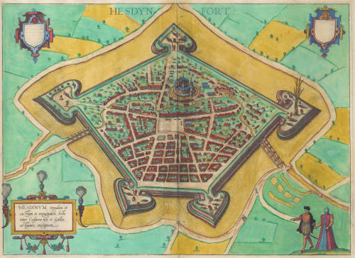
Hesdinum Oppidum et castrum in expugnaile…Artists
Braun, Georg (German, 1541-1622)Hogenberg, Frans (German, 1535–1590)Publication
Civitates Orbis TerrarumDate
1588Process
EngravingImage Size
33 x 40 cmSheet Size
41 x 54 cm
This bird’s-eye plan shows the French town of Hesdin. Published almost thirty five years after the town had been destroyed and rebuilt by Charles V, the plan details the town’s impressive moat and fortifications. It appeared in volume four of the Civitates Orbis Terrarum — the great six-volume atlas of world cities compiled by Georg Braun and engraved largely by Frans Hogenberg, published between 1572 and 1617 — and recognized by scholars as the most important book of town plans and views ever produced, containing 363 engravings of settlements across Europe and beyond.
One of the many advantages eyed by industry of the advent of photography was the reduction in size and replication of maps and technical drawings. Incentivised by the desire to reproduce and share his own paintings in addition to the financial benefits of developing the technology, Charles Nègre pursued a solution to the problem and by 1856 had met with some success.
In 1857 Nègre was commissioned by the Société des Antiquaires de la Morinie, a learned society dedicated to the history and archival record of the Morinie — the ancient territory stretching from the valley of the Canche to the mouth of the Scheldt. The published result appeared as an illustration in the Society’s 1857 edition of Conseils politiques adressés à la Princesse Marie régente des Pays-Bas pour Charles-Quint — a Habsburg administrative text from the era of Charles V, illustrated with a photographic reproduction of the city his forces had erased three centuries earlier.
References
Braun, G. & Hogenberg, F., Civitates Orbis Terrarum, Vol. IV (Cologne, 1588); Tooley, R.V., preface to the facsimile edition (World Publishing, 1966); Duvosquel, J.-M. & Thoen, E., "La destruction de Thérouanne et d’Hesdin par Charles Quint en 1553," Academia.edu (2007)